Embry-Riddle Drone Teams Measure Least Known Parts of Atmosphere, Most Violent Features of Hurricanes

As the warm ocean waters off Florida’s western coast supercharged Hurricane Milton into a Category 5 storm, a small drone clocked wind speeds of 235 miles per hour.
In the storm’s eyewall, where winds are the strongest, the three-pound drone was thrust up and down at speeds of about 100 feet per second. Even for Dr. Josh Wadler, a meteorologist at Embry-Riddle Aeronautical University who has flown into many hurricanes, these velocities were difficult to describe.
“I don’t think anyone knows what that is like. I hope to understand it, but we’ve never measured that before,” said Wadler, an assistant professor in the Applied Aviation Sciences Department who launched the drone from a hurricane hunter aircraft as part of an ongoing research project in partnership with the National Oceanic and Atmospheric Administration (NOAA).
Wadler’s work is one example of how Embry-Riddle researchers are employing uncrewed aerial systems (UAS) to probe atmospheric conditions in areas once considered too dangerous or difficult to fly crewed aircraft. The resulting data could one day help meteorologists improve forecasts and better understand storm dynamics.
Gathering Critical Data Where We Live
The portion of Earth’s atmosphere up to approximately 2,000 meters, known as the planetary boundary layer, significantly influences the weather.
Though it encompasses where humans live, this layer is the least sampled portion of the atmosphere, said Dr. Kevin Adkins, professor of Aeronautical Science and director of the Uncrewed Vehicle and Atmospheric Investigation Lab.
Meteorological observations are provided by aircraft flying at higher altitudes. And on the surface, “we just really have fixed weather stations,” he explained.
But new drone and sensor technology, some of which is being developed at Embry‑Riddle, is finally allowing the planetary boundary layer to be explored.
Last September, Adkins and three of his students took part in a data-gathering campaign held by ISARRA (the International Society for Atmospheric Research using Remotely Piloted Aircraft) in Tulsa, Oklahoma. The campaign sent teams around the city to take measurements using a variety of drones.
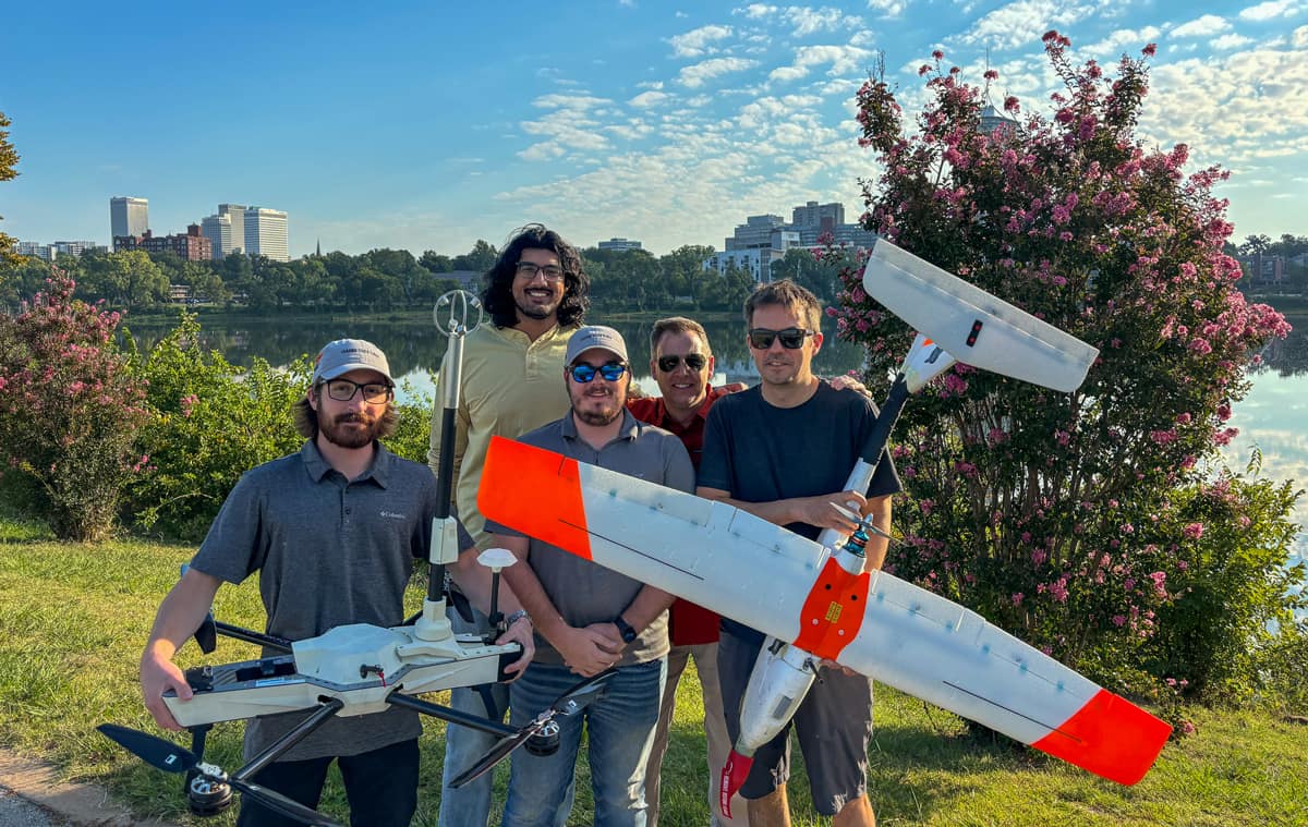
An Embry-Riddle team holds two drones used to take measurements in a campaign around Tulsa, Oklahoma. The team comprised (from left) undergraduate Colin Deputy, Professor Avinash Muthu Krishnan, undergraduate David Zink, Dr. Kevin Adkins and Maciej Stachura, of Black Swift Technologies. (Photo: Embry-Riddle)
Over several days, the Embry-Riddle team flew two aircraft. One was a multi-rotor drone that captured hourly vertical profiles of the atmosphere, including pressure, temperature, humidity and wind speeds. The other was a fixed-wing aircraft that launched three times a day and flew horizontally at various altitudes to calculate turbulence characteristics.
“When we were flying the fixed wing, we also saw a large amount of wind shear as we were stepping our altitude upwards,” said David Zink, who is earning his bachelor’s degree in Uncrewed Aircraft Systems with a minor in Applied Meteorology. “You understand these things happen, but just seeing how the wind profile changes as you go up in real time was very interesting.”
The Tulsa flight operations lasted longer and were more complex than those generally conducted on campus, the participants said. Aircraft were permitted to reach an altitude of 1,300 feet, which is 900 feet higher than is typically allowed. Flights took place in busy airspace that included other teams’ drones, aircraft from a nearby airport and a medical rescue helicopter.
On one morning, the aircraft recorded a “lovely temperature inversion,” said Avinash Muthu Krishnan, an assistant professor of Aeronautical Science.
Air temperatures typically decrease the higher you go, but temperatures slightly increased “as we went up,” Krishnan said. “Then as we looked at our flights throughout the day, we saw a return to that normal temperature decrease later on in the day.”
Part of the campaign was also to explore how temperature varied across different parts of Tulsa. This includes the heat island effect, where buildings and paved surfaces in cities cause temperatures to be higher than in greener outlying areas.
While the collection of such measurements is still in its infancy, such data could one day improve the accuracy of forecasts by increasing the number of observations that are added to numerical weather models, Adkins explained.
“There is a real need for the understanding of this lowest portion of the atmosphere,” he said. “When we better capture the physics of the surface environment, we will significantly improve forecasts.”
Entering the Eyewall to Understand Hurricanes
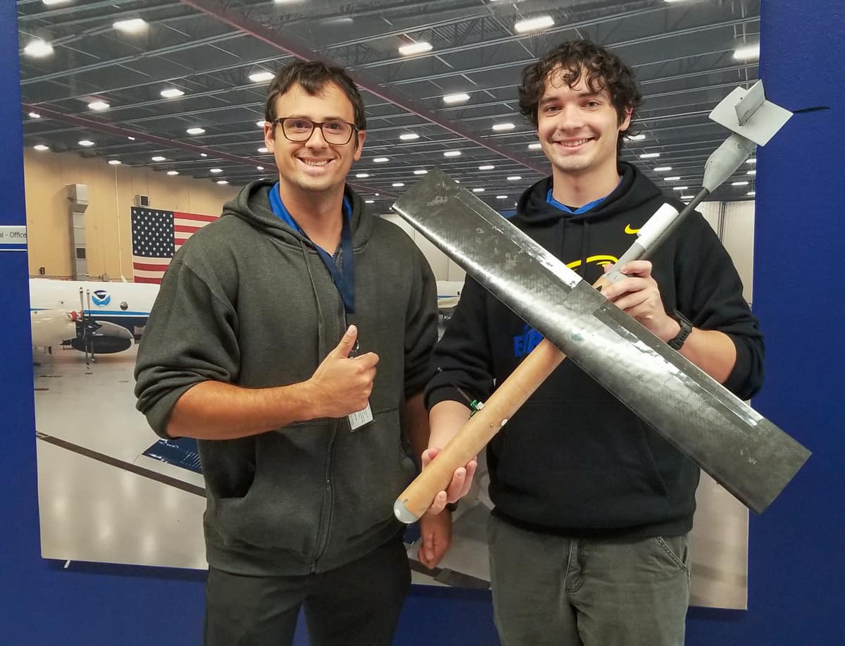
Dr. Wadler and undergraduate Meteorology student Chris Deloach pose with one of the Black Swift S0 drones. (Photo: Embry-Riddle)
As NOAA hurricane hunter aircraft flew into four storms, meteorology researcher Dr. Wadler and his team launched drones to penetrate the zone closest to the ocean’s surface, where evaporation pumps heat into the storm, driving powerful winds and rain.
But exact measurements of the conditions from the ocean’s surface to 1,000 feet above sea level, where this crucial energy transfer occurs, have been nearly impossible to obtain. NOAA WP-3D Orion Hurricane Hunter aircraft fly into storms at 8,000 to 10,000 feet. Probes with parachutes, known as dropsondes, can be released from the aircraft, but the devices can only capture a snapshot of conditions as they descend into the ocean.
“It’s a measurement void,” Wadler said.
Drones offered a promising solution for measuring in more locations and at altitudes where crewed aircraft would never fly. Yet deploying drones to record the inner workings of a hurricane presented serious challenges, he said.
The team needed to drop an aircraft contained in a cylinder from a plane flying at more than 250 mph inside a hurricane. The drone then had to communicate with the hurricane hunter aircraft and survive some of the most intense storm conditions before plunging into the ocean.
“This is very hard science and a very hard thing to do, and you don’t get many chances,” Wadler said.
In the past three years, two drones, the Altius-600 and the Black Swift S0, have launched from the P-3 Orion. This past hurricane season, Wadler and his team deployed the Black Swift S0, which is designed for autonomous flight.
A three-pound drone that resembles a torpedo, the Black Swift S0 begins its journey in a tube, with its single wing folded parallel to its body. The tube is dropped from a chute and tumbles away from the aircraft, triggering its parachute. The tube then falls away and the drone’s wing springs into position. The parachute detaches and the drone descends to 5,000 feet or below.
A member of the Black Swift Technologies team onboard the aircraft controls the drone. Wadler instructs the drone operator while watching a real-time map of the drone’s flight pattern and the data being recorded.
The drone is then directed to find, for example, the highest winds in the eyewall.
“In the eyewall, it will do what is called step descents. So it will stay at 5,000 feet for ten minutes, and then drop to 1,000 feet,” Wadler said. “And while it's at that altitude, it's trying to find the maximum winds.” The drone also collects data on pressure, temperature, humidity and sea surface temperature.
During the 2024 hurricane season, Wadler and his team launched the drone 19 times, the most launches to date in a single season.
“This was by far our best season of making measurements, we have so much data,”
Wadler said. “But it was also a devastating year.”
Assisting Wadler was undergraduate Meteorology student Chris Deloach, who was aboard a P-3 Orion that flew into Hurricane Rafael while it swirled as a Category 2 storm in the ocean waters off Florida’s western coast.
“Being able to do this so early in my career would only be possible at Embry-Riddle and with Dr. Wadler,” Deloach said.
Wadler said that the immediate goal is to prove that drone deployment and data collection are possible and effective in hurricane hunter observations. In the future, the data could improve the precision of forecasting and the tracking of hurricanes by helping scientists better understand their physics.
Now Wadler and his team are beginning to synthesize the data recorded over this past season. One focus will be the 235 mph winds and “vertical velocities” of 100 feet per second from the drone that flew into Hurricane Milton’s powerful eyewall, he said.
“My hypothesis,” Wadler said, “is that we measured the highest amount of turbulence ever recorded on Earth.”