Chasing Air Taxis: Eagles Simulate Drone Routes to Advance NASA Research


 Mike Cavaliere
Mike Cavaliere
/
Mike Cavaliere
Feb 14, 2022, 11:31 AM
Researchers at Embry-Riddle Aeronautical University helped bring the goal of widespread drone delivery service and air taxis closer to fruition recently, by flying small un-crewed aircraft systems (sUAS) along simulated delivery routes in Florida. The exercise proved the viability of the hyperlocal weather-prediction tools needed to fly autonomous systems in populated areas.
“Without good weather products, these aircraft may be unnecessarily grounded, delaying the delivery of goods and services,” said Dr. Kevin Adkins, associate professor in Embry-Riddle’s College of Aviation.
With most UAS weighing less than 55 pounds, even mild gusts of wind could disrupt their flight. Especially in metropolitan areas, where tall buildings can create unpredictable weather forces, more sophisticated forecasting software is needed to ensure that aircraft can operate both safely and efficiently.
“Micro weather forecasting is essential with drone deliveries,” said Avinash Muthu Krishnan, a Mechanical Engineering doctoral student who helped design and build the meteorological software equipped on the drones. “With drone delivery also comes automation of drones for beyond-visual-line-of-sight flight. You need to be 100% with the success rate of the drone flying uninterrupted to and back from a destination. Without weather predictions along the route, a lot of uncertainty is added.”
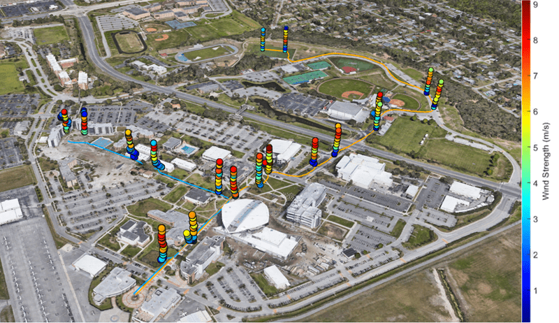
Observations from the field: Three meteorologically instrumented drones were flown along two separate paths through Embry-Riddle’s Daytona Beach Campus (the blue line traces a simulated urban package delivery route; the orange line represents a suburban delivery route). The drones measured the wind speed, along with other meteorological parameters, at increasing altitudes at each marker location. (Photo: Marc Compere)
The research, which started in 2020 on Embry-Riddle's Daytona Beach Campus, endeavors to filter weather data from the National Oceanic and Atmospheric Administration and nearby ground stations through 3D models of urban environments to refine forecasts to specific locations. The team’s General Urban area Microclimate Predictions tool (GUMP) leverages machine learning and Computational Fluid Dynamics (CFD) simulations to convert computer wind flow fields into an intuitive risk map for sUAS operators.
“Think of air taxis or drone delivery and you probably think of hundreds of small aircraft flying relatively low over large metro areas,” Adkins said. “This is a dense operation in a part of the atmosphere where conditions are constantly changing. This will be a brand new environment for aviation, and tools like GUMP are needed to help make it efficient and safe.”
The development of such tools are also helping students visualize careers in the field.
“Finding a job in the UAS sector is really the dream for me, and most of what this project entails is exactly what I would love to do for a living,” Krishnan said. “This technology is relatively new, with discoveries changing our strategies and plans regularly. Hopefully one day I can make a significant contribution to the field.”
Dr. Dan Macchiarella, professor of Aeronautical Science, is also playing a key role in the project, building the 3D models. Dr. Marc Compere, an associate professor in Embry-Riddle’s College of Engineering, assisted Krishnan in the development of the instrumentation and post-processing of the data. Multiple undergraduate Aeronautical Science students are conducting test flights.
Other partners in the project include Intelligent Automation, A BlueHalo Company and AvMet Applications, Inc.
Posted In: Aviation | Computers and Technology | Engineering | Research | Uncrewed Systems