MicaPlex Tenant Supports 'Beyond Visual Line of Sight' Drone Survey
 Ginger Pinholster
Ginger Pinholster
/
Ginger Pinholster
Jul 29, 2019, 7:37 AM
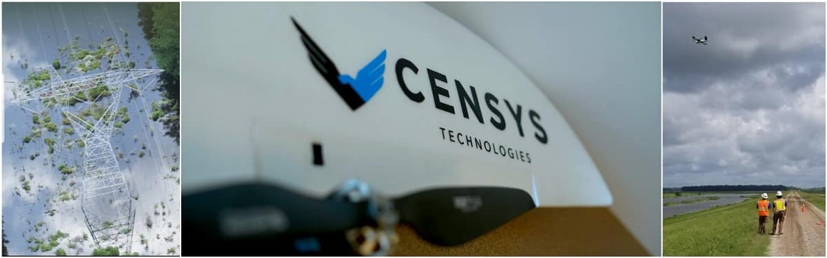
Advanced unmanned aerial systems recently scanned more than 51 miles of hurricane-ravaged power lines – beyond the drone operator’s line of sight – in only six hours, thanks to technology developed by Censys Technologies Corporation, a high-tech tenant in Embry-Riddle’s Research Park.
The assessment, conducted by Censys Technologies’ client Soaring Eagle Imaging, revealed the extent of damage to critical energy infrastructure following Hurricane Barry, which made landfall in Louisiana on July 13, 2019.
By law, drones can only be operated within the operator’s line of sight, but Soaring Eagle Imaging (SEI) had secured Federal Aviation Administration (FAA) approval to assess miles of power lines for a major Louisiana energy provider, explained Trevor W. Perrott, an Embry-Riddle alumnus and CEO of Censys Technologies.
Only about 30 commercial entities currently have approved BVLOS waivers in the United States, making such flights rare, Perrott said. With more than 30,000 manned aviation hours and 3,000+ hours operating drones, “SEI brings a strong safety culture to every operation,” he noted. “This is reflected in the 17 emergency Beyond Visual Line of Sight waivers they have been granted in the past.”
For the recent post-hurricane survey, SEI used a Censys Technologies Sentaero v2VTOL (vertical takeoff and landing) drone, with no remotely located visual observers, after determining that it was safe to do so. “This enabled identification of the scope of damage and corresponding locations, helping facilitate swift repairs” to power lines, Perrott said.
SEI CEO William Paden commended Censys Technologies. “The level of professionalism from the entire Censys team is the reason our organization is able to continually set new standards in the unmanned aerial vehicles realm. The constant communication with the leadership and engineering team was instrumental in the aircraft performing at the level it did.”
Perrott said, “I’m ecstatic to see a great partner and customer of ours employ our technology with such an emphasis on safety to deliver exceptional value to energy asset owners, and I’m confident we’ll continue to set standards together.”
The company has focused on developing long-range, high-efficiency UAS capable of flying without visual observers (BVLOS). Such technology offers a way to complete large-scale aerial inspections more efficiently than short-range quadcopters and more cost-effectively than manned aircraft or satellites, Perrott said.
With a wing span of 83 inches, the Censys Technologies Sentaero v2VTOL drone has a range of 50 miles and it can cruise at 40 miles per hour for 1.25 hours.
Posted In: Applied Science | Aviation | Security Intelligence and Safety